|
Go on try this one out, I know it's 16 miles but it's totally flat and the variety of scenery and history
will astound you, plus there are lots of great places to stop for a drink or a meal along the way.
Leave the A27 to take the Eastern Rd towards Portsmouth, shortly
on the left you will see a quay jutting into Langstone harbour, turn left here under the 6ft barrier and park your car.
From where you left your car, head north up the gravel path which skirts
the sea wall and Langstone harbour beyond, cross over the access road for the aggregate company and continue beneath the conifers,
keep following the path until it emerges onto the Eastern road on the southern side of the harbour bridge. Be extremely careful
crossing the very busy road, and join the path which now skirts the southern edge of the strip of water which separates Portsmouth
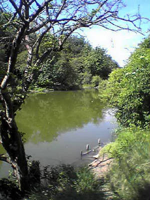
from the mainland (Ports Creek). You will pass several lakes on your left. This area is called Hilsea Lines and there are
fortifications hidden in the shrubbery behind those lakes. Keep walking until you emerge on a small road which crosses a bridge
over the creek and motorway. Do not cross the bridge, just cross the road to rejoin your path as it skirts more of the moat
or lake on your left. When you reach the car park on the busy London road, cross the zig zag pedestrian bridge and follow
any of the paths around Hilsea Lido until you end up skirting the creek again.
Follow the cycle path through Alexandra Park passing the Mountbatten centre athletics stadium on
your left, keep to the cycle path signed City Centre through the car park and alongside the Greyhound
Stadium, at the far end of which turn left into Target Rd then right into Tipner Rd which then bends around to the right becoming
Tipner Lane and passes under the M275 motorway. Look out for the path on your left which runs along the edge of the motorway
one side and Tipner Lake (part of the harbour) on the other. Eventually this will bring you up onto Whale Island
Way, follow this road passing first the Ferry disembarkation yards, then the marshalling area for vehicles waiting to board
the cross channel ferries. Keep on the footpath alongside the A3 Mile End Rd and follow it right handed into Hope St
at the roundabout. The wall surrounding the Royal Naval dockyard is now on your right, keep going past the Unicorn Gate which
is the main dockyard entrance, then on reaching the traffic lights at the HMS Nelson junction, turn right into Queen St. You
will pass a large maritime club on your left and the Historic Dockyard on your right, the road bends sharply left and becomes
The Hard, note HMS Warrior moored to your right. Walk past the train and bus stations then descend a slope and turn right
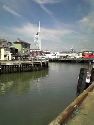
through a tunnel to bring you out in the fantastic Gunwharf Quays shopping centre. If you want to visit the Spinnaker
Tower keep straight on to the waters edge, if not take the first left , cross a wier , turn left then immediately right
and exit the residential part of Gunwharf through a large set of gates. Turn right and pass the IOW ferry terminal on your
right. Keep going past the fishermens buildings and public toilets on your right is the Camber Dock usually full of fishing
boats and pleasure craft. follow the path between the dock and the attractive residential buildings and you will emerge onto
Broad St.
A right turn to the end of Broad St, solely for the views and marvellous pubs is very much recommended, however
our route continues up the steps opposite onto the walls which we follow left handed, soon we pass through the fairground
at Clarence Pier and then along the seafront promenade Southsea Common to the left of you. The promenade passes behind "The
Blue Reef" Aquarium, D Day Museum and the Pyramids leisure pool and continues under the canopy of South Parade Pier and
on towards Eastney passing the Canoe lake, model village, putting green and Royal Marines Museum on the left.

At the end of the promenade is a public convenience and the road turns sharp left, continue along the road
as it bends left again passing the Eastney pumping station on your right. Soon you will see a tree lined path through Bransbury
Park on your right. Cross the park and continue straight on along Ironbridge Lane to it's end, here you must turn right onto
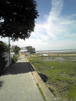
Locksway Rd and pass both St James hospital and a Portsmouth University campus on the left. Just after Ye Old Oyster House
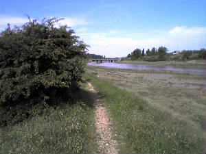
pub and next to the Thatched House pub car park is a fenced footpath, which you follow to reveal Milton Lock and lovely
views of the boats on Langstone Harbour as you skirt it's edge.
The path soon opens up onto a heath with several lakes (popular with the local swans), on your left, and
the harbour still to the right. The footpath soon closes in on the busy Eastern Rd, which it runs alongside right back to
where you left your car.
I think you'll agree that you don't feel as if you have covered
such a large distance due to the good walking surface , flat terrain , interesting and suprising scenery. This
is my favourite walk, I hope you enjoy it.
|
